• Home
  • Travel
  • Life Style
    • Category
    • Category
    • Category
  • About
  • Contact
  • Download
Powered by Blogger.

C Travel Adventures

facebook google twitter tumblr instagram linkedin
U-Bein Bridge
We had, admittedly, not really seen much of the sights of the city of Mandalay itself, though having fully experienced the water festival however, we felt that this was a suitable trade-off.  There was one more location that we wanted to (re)visit however and that was U-Bein Bridge.  We had already seen it at sunset, but we had heard that the most beautiful time to see it was sunrise, when it is quieter and the monks cross it to collect their daily alms.  This meant checking out of our hotel at about 5.30am, but that wasn’t too much of a hardship considering that it would allow us to see more throughout the day and reach our eventual goal (Inle Lake) earlier.  While the sunrise itself was pretty hazy, arriving at the bridge early was well worth it for the peaceful calm at the lake and the wonderful pictures we were able to capture, my favourite of which is above.
A random religious hill top on
From here it was to be a long eight-hour drive through the hills to Inle Lake.  I had asked Jimmy if he was willing to stop off about three-quarters of the way through the journey at a place called Pindaya, a major site of religious pilgrimage which is based around a cave, stuffed full of Buddha statues.  There are thought to be over 8,000 statues of the Buddha, donated and collected from all over the world. Tourists have to pay a $5 entrance fee, but this is well worth it as the caves alone are impressively dramatic, not to mention the amount of golden Buddhas inside them.  We only stayed for about an hour or so before continuing the remaining two hours to Inle - for anyone with a large amount of time at the lake, Pindaya would make a good half-day excursion.  We arrived at about 6pm at the town of Nyuang Shwe, the tourist hub at the northern end of the lake.  While there was no time to go out on the lake itself, we were able to wander around the town a little bit, grab some food and then took some beers back to the hotel terrace.

Pindaya Caves

Pindaya Caves

Share
Tweet
Pin
Share
No comments
Both sides of the island at once - the view from Violet Hill
The hiking book that I purchased back in October contains a total of 15 hikes, spread across all of the territory.  It had always been my intention to complete all of them and as my final month began, I realised that I would have to get a move on to achieve this.  As a result I decided to stitch a few of these hikes together - a process that was made easy by the excellent “Historical Hikes of Hong Kong” book by David Pickerell that I had been using.  I left the campus early and was at the bus station beneath the IFC by 10am.  The start point for both hikes was at ‘Hong Kong Parkview’, a luxury residential area locating on the heights above the harbour.  In order to get there I would have to take a Stanley-bound bus from Central.  Unfortunately, having aimed to get the number 6, I caught the number 6X.  The 'X’ apparently symbolises the fact that the bus route goes through the tunnels underneath the island, rather than through the passes above it, where the hike starts - and I therefore ended up wasting an hour or so, having gone directly underneath the trail-head, getting a taxi from Repulse Bay to rectify my mistake.

The start of the first hike - steps up to the right
Starting from a well-marked point next to Parkview, I followed signs for the Violet Hill and Tai Tam reservoir, the former of which I climbed to the top of and the latter of which I spent the first half of the first hike skirting around.  It was reasonably busy, being a Saturday morning, but there were still plenty of moments where there was nobody else about.  It soon became clear that this was going to be one of the most spectacular hikes I had done, as each turn brought better and better views of all of Hong Kong Island - first over Victoria Harbour on the north side, then over Aberdeen, Repulse Bay and Stanley on the south side, not to mention the views over the beautiful reservoirs and forests of Tai Tam Country Park.  After a steep initial climb, the ascent to Violet Hill wasn’t too hard and from there it was a gentle descent towards 'The Twins’ (a pair of very steep-sided peaks) and Repulse Bay.  At the foot of the twins, footpaths head off in all directions.  I took the right pass towards Repulse Bay, following signs for Wong Nai Chung Reservoir.  The path was now flat and followed the south side of the island with views towards  Ocean Park, Lamma Island and in the distance Cheung Chau.  About two and a half hours after I began I found myself at the Wong Nai Chung Reservoir - a tiny reservoir that was deemed too small to be worth maintaining for the purposes of drinking water and is now a boating lake.  From here it was about a 400m climb back to Parkview where I started and would also begin my second hike.

The start of the second hike - through the arch
The second hike was to head west along Hong Kong island, towards the peak, before veering north and east again, finishing at Quarry Bay station.  This hike again started with a steep hike up towards Jardine’s Lookout.  Along the way, a plaque marked the position where Canadian soldiers fought of the Japanese invasion during the war - with a Victoria Cross being rewarded to a Sergeant-Major Robert Osborn, who through himself on a grenade to protect his comrades.  After about half an hour of climbing I made it to Jardine’s Lookout, which had one of the best views of the harbour I have seen.  The peak’s name came from the fact that it used to be where representatives of Jardine Matheson (the opium house that was pivotal in the foundation of Hong Kong) used to come to wait for ships to arrive from Europe.  Legends has it that their ships used to signal insider information about the European stock markets to the hill, allowing the company to gain a commercial advantage on the Hong Kong markets…

The hike now headed downhill steeply towards a large quarry (after which Quarry Bay station is named) and with Tai Tam reservoir always visible to the right.  After another steep climb along the side of the quarry I arrived at a hill with views over the lesser-known east end of Victoria Harbour, from where I descended to Quarry Bay MTR station and headed back to the campus.  While both hikes together were quite a lot of work (about five and a half hours of reasonably intense hiking in total), it was definitely worth seeing both of them together and an achievable goal for anybody wanting to see a different side of Hong Kong while being pushed for time.

Tai Tam Reservoir
Repulse Bay and the south side of the island
Victoria Harbour from Jardine’s Lookout
The eastern end of Victoria Harbour

Share
Tweet
Pin
Share
No comments
The perks of a family visit - the pool at the Metropark Hotel, Causeway Bay
On the 2nd April, a small group of us sat in the university canteen and mulled over the fact that April was going to be a hugely busy month and that two days into the month we would have precious little free time until May.  For me, the busyness came as a result of having two midterms, the final submission of my Final Year Research Project, two family visits and a ten day trip to visit Burma (for which you can find the blog at www.colesburma2014.blogspot.hk).  I will be the first to admit that this busyness was mostly my own fault, but that didn’t stop if being a month that really lived up to HKUST’s nickname of the “University of Stress and Tension”.  I will admit that the above photo doesn’t exactly conjure images of me working hard, but March and April have been probably the most mentally gruelling of my academic career.

First visit to Aberdeen 
The arrival of my uncle and cousin at the start of April and my mum, dad and brother at the end of April was a welcome distraction from the workload, though did put me in the position of playing tour guide by day and catching up on work and revision in the library in the early hours of the morning and also meant that I had to take my laptop to Burma to finish off my FYP report.  I managed to not miss the deadline however and, despite feeling that I was going to be eaten alive, managed to do a reasonable job of the corresponding ‘defence’ presentation in front of a panel of professors.  The FYP has been a constant weight on my mind since September - I was forced to work on it on Christmas Eve, Boxing Day and in both India and Burma, not to mention all of the Saturday morning meetings and late night library sessions.  Having finished, it almost feels like the term is over - though with four modules left to finish I keep having to remind myself that there is still more to do.  That said, post submission date, I was able to totally ignore university work by staying at the family’s wonderful hotel (the Metropark on Victoria Park) and doing sightseeing.  In addition to a visit to Macau (mentioned elsewhere) I was also able to see Aberdeen for the first time and spent a lot more time on the island around Causeway Bay than I ever had.  In conclusion, a mixed month - on one hand excruciatingly hard work and on the other, wonderful due to being able to spend time with family, visit Burma and eventually break the back of the academic workload.

Mum’s birthday dinner at Saigon Vietnamese restaurant, Stanley

Share
Tweet
Pin
Share
No comments
The iconic Ruin of St. Paul’s Church, Macau
The arrival of the family allowed me to re-see Hong Kong through the eyes of a tourist for a week or so.  This served as the perfect excuse to finally get around to visiting nearby Macau, the former Portuguese territory that is an hour’s ferry ride from Victoria Harbour.  While not a tourist attraction on the same scale as Hong Kong itself (and with a population a tenth of the size), the territory is a popular and convenient day trip.  It has also established itself as one of, if not THE gambling capitals of the world - by some measures overtaking Las Vegas.  As we are not really a family of gamblers, we decided to head over in the day to see the old colonial sights - the ferries run all through the night to cater for those who want to visit the other side of Macau.  The histories of Macau and Hong Kong are linked and are reasonably similar.  The Portuguese, who were the first major European colonisers in Asia, were granted the territory as a trading base by China in 1550 - hundreds of years before the British turned up in Hong Kong.  The territory was in part granted in thanks for the Portuguese successfully cutting down on piracy in the region - a far more honourable acquisition of territory than the British Opium War route…  Macau spent many years as the Portuguese equivalent to British Hong Kong, but was soon eclipsed and by the end of the 20th century the Portuguese were happy to hand it back in a deal similar to that ceding Hong Kong back to China.

Guia Hill lighthouse
After passing through the border in Hong Kong easily (due to the complicated nature of the Chinese Specially Administrative Regions, SARs, we were actually crossing a border while remaining in China), we caught one of the fast ferries which run every 15 minutes and cost about £20 for a return ticket - pretty steep by the transport costs that I have been used to in Hong Kong.  Due to the close ties between the two SARs, the Hong Kong dollar is accepted everywhere at a 1:1 exchange rate to the Macau Pataca - a currency that we didn’t actually see all day.  Upon arrival at the Macau ferry terminal we decided to proceed on foot to climb Guia Hill, the tallest point in the territory to see the lighthouse (the first European style lighthouse in Asia) at the top.  In hindsight it would have been better to do this journey by public transport or taxi as we spent much of it walking beside a busy road, but we got there eventually and were treated to good views over the whole territory and towards mainland China which is easily visible.

The guns of Monte Fort and the Grand Lisboa Casino
From here we got the cablecar down to street level and ambled through the streets to the iconic ruin of St Paul’s Church, one of the main tourist sights in the territory - only the façade of the building remains as the rest was destroyed by fire many years ago.  The church marks the beginning of the old colonial district, which is overlooked by the large Monte Fort, once the seat of Portuguese military power in the region and now home to the Macau History Museum.  The guns of the fort still point out in all directions and amusingly appear to be trained on many of the garish new casinos - I like to think that this was done deliberately by the curator of the museum…  We had our lunch on the steps leading up to the ruins of St Pauls - a combination of Chinese and Portuguese street food, finished off with a Macau egg tart, a local delicacy.  The rest of our time was spent ambling aimlessly - first through the beautiful (if highly renovated) colonial district, past old churches and government buildings and then through one of the main areas of casinos.  While impressive, the casinos felt very dated somehow - like they were built to a very specific architectural ‘modern’ style that time has proven to not look modern at all.  The over the top features and insistence on bright colours and gold leaf made it feel like we were walking through a movie set from the 1970s.  If this is what Las Vegas is like, then I will admit that I am in no rush to get there.  We grabbed a taxi (they all accept HKD) back to the ferry terminal and having spent about five hours in Macau, made our way back to Hong Kong.  It was definitely worth the trip for me, having seen so much of Hong Kong, and it was certainly different to anything that HK has to offer.  'Different’ isn’t necessarily 'better’ however and I would suggest that the day trip is only worthwhile for people who are spending at least four full days in Hong Kong itself.
The Colonial District

The Grand Lisboa Casino


Share
Tweet
Pin
Share
No comments
The Peak - any excuse to climb up there
Following on from a highly successful hike to the Lion Rock in Kowloon, myself and Sophie decided to capitalise on the good weather and lull in uni work by going for a second hike in three days.  This one was set to be a little more sedate than the Lion Rock, starting at Victoria Peak and heading eastwards along the island towards Aberdeen Reservoir and the Wan Chai gap.  Having experienced the peak tram enough times for its novelty to not be worth queuing for, we got the number 15 bus from Central station (underneath the IFC) up to the Peak.  In many ways this is actually a more scenic option, especially if you can get a seat on the top deck of the bus.  After spending the obligatory quarter of an hour seeing how many different angles we could get of Victoria Harbour, we walked behind the large shopping mall at the Peak and made our way east.  We soon passed through the luxury residential area (and the cute fire station that serves it) and were by ourselves on a shaded footpath heading downhill.

The beauty of hiking in Hong Kong as a city (and what in my opinion makes it so unique) is that in the space of a few minutes you can leave a major tourist centre and find yourself in your own little piece of isolated wilderness and this was no better proven than the hike today.  Being a Tuesday morning, the only people we only saw a handful of other hikers and had soon escaped the roar of traffic from the city.  For the most part the hike was easy going and while the views were not particularly spectacular, the charm of this hike was the knowledge that we were doing it essentially in the middle of one of the world’s financial capitals.  It took around three hours to get from the Peak down to Aberdeen Reservoir, where there were some picnic spots and options for further hiking - we had the choice of going over to Aberdeen or clambering back up the Wan Chai gap to meet another bus coming back down from the Peak to Central station.  We chose the latter as we both had other plans for the afternoon, but agreed that the brief hike had been a worthwhile half-day excursion and had shown yet another side of the city.  The hike was taken from my ‘Historical Hong Kong Hikes’ book by David Pickerell - a book that I can thoroughly recommend purchasing.  Photos of the hike below:


Aberdeen Reservoir


Towards Aberdeen

Share
Tweet
Pin
Share
No comments
The Irrawaddy River overlooked by Sagaing Hill
Mandalay has achieved a legendary status amongst travellers as a place whose very name conjures up images of exotic lands - up there with places like Timbuktu or Shangri-La.  This is thanks mainly to the poem by Rudyard Kipling (who it turns out never actually made it to the city) and some might argue that the reputation is not actually particularly well deserved.  It certainly isn’t a particularly old city, with the current urban centre only really being settled for a few hundred years.  The surrounding area has, however, always played an important part in the history of Burma and is home to some of the country’s most iconic and significant sites.  After the fall of Bagan, the country split into two kingdoms - one in the south called Pegu, close to Yangon and another in the north called Ava (known in old Burmese as Inwa).  Strategically situated on the banks of the Irrawaddy, opposite the important religious centre of Sagaing Hill, some believe that Inwa may have been not too dissimilar to a smaller version of Bagan.  The town is 20 minutes south-west of Mandalay and seemed like a good place to start our day, making the most of the van as always.

Ruins of Inwa
Inwa does not immediately give the feel of being a former capital city, with ruins located sparsely across what is now essentially a village.  The site has been hit by several earthquakes which have damaged or partially destroyed some of the buildings.  As a lesser visited tourist site, in a lesser visited country, we were able to happily wander around these ruins without having to pay any entrance fee and didn’t see anybody else around.  In amongst the crumbling ruins and paddy fields were also ancient wooden and stone temples, both used and unused.  One of these monasteries, an impressive teak structure, also served as a school and was full of desks, world maps and posters outlining the English alphabet.  The rafters of this large monastery were stuffed with bats and there was a stark contrast between the thick, stuffy air that belied its past and the shiny laminated English posters that (maybe) pointed towards its future.  On our way out of the temple we were ambushed by a truckload of local children who all wanted a good shot at drenching the westerners.  We got our revenge as best we could with the water that we had, but were too wet to get back into the van and told Jimmy (the driver) to let us walk ahead in the sun for a bit to dry off.

The old teak temple
The Buddhist university at Sagaing 
There was still a lot more to see in Inwa, but our time was reasonably tight so we drove in amongst the ruins to the Irrawaddy at the northern edge of the town for photos before stopping for lunch at a local restaurant (we had given up on menus and taken to just asking for them to bring us a reasonable amount of food, which has been working remarkably well…)  Our stop for the afternoon was Sagaing, on the opposite side of the river, meaning that we had to cross on of the great bridges further upsteam.  The town is based around a large hill, covered in temples, and has been a centre of religious teaching for hundreds of years.  This was emphasised by our first stop, a Buddhist university, where it is possible to take diplomas in a variety of theological courses.  It is officially called the ‘Sitagu International Buddhist Academy’, for anybody who is reading this and thinking of enrolling… The temple classroom that we had seen in the morning and the university were proof of how traditionally education in Myanmar was the responsibility of monks - a system that was progressively destroyed by the British and (to some extent) the generals.  Jimmy continued on our tour of Sagaing by driving up to the top of the hill where a large temple offered spectacular views over the Irrawaddy, Inwa and towards Mandalay in the distance.

View from Sagaing Hill over the Irrawaddy bridges
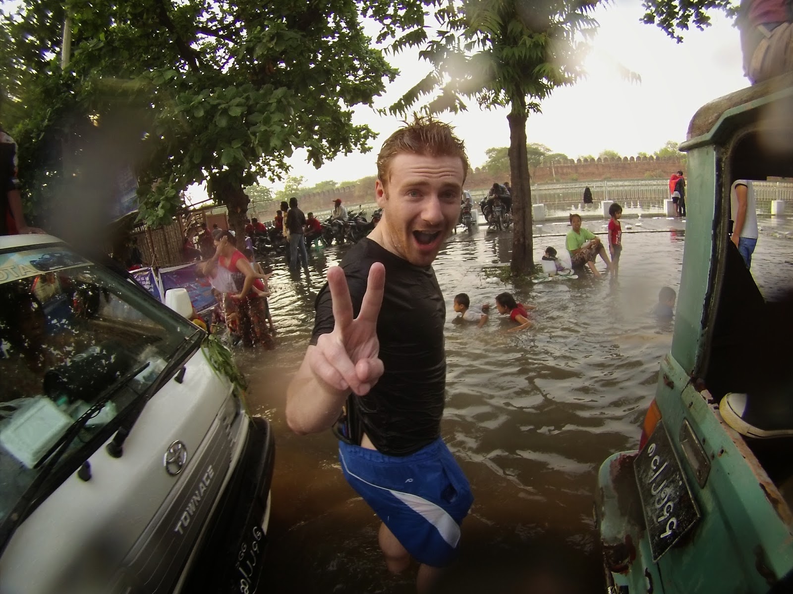
That concluded our tour of the major sites around Mandalay and we decided that it was time to head back into the city itself.  The excursions had definitely been worthwhile however, especially considering how important both locations have been in the history of the nation.  Our return to the city was to be no less cultured, but potentially far less dignified, as we had allocated the rest of the day to fully experiencing the water festival.  Thingyan, the Burmese name for festival that occurs just before the new year, is comparable to similar festivals held in Thailand, Laos and Cambodia.  The period is a national holiday in which people traditionally are free to spray total strangers with water.  This ranged from young children with buckets throwing water at motorcyclists passing outside their houses, to the city centres were thousands of people sprayed high-powered hoses into the streets from large purpose-built structures.  The impact on Mandalay was absolutely astonishing - the streets were flooded with water up to knee-level in some places and traffic in the centre had ground to an absolute halt, with people dancing all over the stationary cars.  Only the photos (taken from Kristine’s go-pro), can give any indication of the absolute chaos of the festival:

The flooded streets of Mandalay 
Dancing of a car bonnet
One of the temporary water-spraying platforms

Your intrepid blogger on the flooded streets of Mandalay


Share
Tweet
Pin
Share
No comments
Mount Popa
Having finished yesterday with a sunset panorama, we decided to follow up with the sunrise.  This meant getting up very early and making our way to the temples before 6am.  We had no particular location in mind and (with plenty to choose from) clambered our way up the side of a temple where there were no other people around.  The sunrise itself was not that spectacular admittedly but it was still a wonderfully peaceful scene to admire the temples rising above the haze in the twilight.  Having risen so early we made our way back to the hotel for breakfast and then checked out for our next major journey, this time to Mandalay.


A early start at the temples
The full team at Mout Popa
In order to make the most of our hired vehicle, I had asked the company to factor in a few diversions along the lengths of our major journeys to allow us to see more of the country than your average visitor.  This journey was to be broken up with a visit to Mt. Popa, a major religious site located within a national park of the same name.  The site, a temple perched on a rocky pedestal, is one of the iconic pictures from Burma but is not necessarily easy to get to without private transport – making a visit all the more tempting for us.  It took us maybe an hour and a half to drive from Bagan to the village beside the pedestal where we were greeted with a massive traffic jam that forced us to proceed on foot and expose ourselves to being sprayed with water, as the festival was in full swing.  As daunting as the climb appeared to be from a distance, the staircase to the top was covered and easily climbable – even with the phalanxes of monkeys that guarded the path.  The views from the top over the countryside were impressive, but the temple itself was surprisingly a bit grim – dirty, crowded and a long way from the usual serenity found in Buddhist religious sites.


Dinner in a lake
After a few hours at Mt Popa we continued on our journey on the “Road to Mandalay” – a road that is entirely devoid of the romance that it has garnered from Rudyard Kipling’s poem, being for the most part flat, straight and featureless.  It was perhaps another four hours from Popa to Mandalay and as we arrived the sun was just beginning to set.  We entered the city through the south western suburbs, home to several lakes, one of which contained the iconic “U Bein Bridge” – the longest teak wooden bridge in the world and another of Burma’s most photographed locations.  The water festival was now evident everywhere, with groups of children lining the road and covering every passing car (and motorbike) with buckets of water.  At the lake we found that a range of restaurants had been set up (presumably for the festival) in the lake itself, with tables positioned in several feet of water.  This was too interesting (and ridiculous) a place for us to not try it out, even if it meant breaking every rule of avoiding food poisoning… After dinner we had a look around the bridge itself, ambling all the way across and back for photos and to chat with inquisitive locals before watching the sunset and making our way into the centre of Mandalay to the Royal City Hotel where we would be staying.
Sunset at U Bein Bridge

Share
Tweet
Pin
Share
No comments
Newer Posts
Older Posts

Search This Blog

About me

About Me


Aenean sollicitudin, lorem quis bibendum auctor, nisi elit consequat ipsum, nec sagittis sem nibh id elit. Duis sed odio sit amet nibh vulputate.

recent posts

Follow Us

Blog Archive

  • ▼  2017 (7)
    • ▼  October (7)
      • South Africa’s 44 blue flag beaches for 2017
      • Europe’s most glam holiday destinations is French ...
      • Alcohol helps you speak foreign languages better, ...
      • Government to cut pilot evaluators for large airli...
      • Nepal POKHARA Day#3
      • Nepal RAMKOT Travel Adventure - Day #2
      • Nepal Bandipur Travel Adventure - Day #1
  • ►  2014 (76)
    • ►  November (8)
    • ►  August (6)
    • ►  July (5)
    • ►  June (10)
    • ►  May (15)
    • ►  April (1)
    • ►  March (4)
    • ►  February (10)
    • ►  January (17)
  • ►  2013 (12)
    • ►  December (1)
    • ►  November (6)
    • ►  September (4)
    • ►  August (1)
  • ►  2012 (27)
    • ►  September (10)
    • ►  August (15)
    • ►  July (1)
    • ►  May (1)
  • ►  2011 (73)
    • ►  September (8)
    • ►  August (15)
    • ►  July (3)
    • ►  June (11)
    • ►  May (24)
    • ►  April (3)
    • ►  March (3)
    • ►  January (6)
  • ►  2010 (27)
    • ►  November (11)
    • ►  September (9)
    • ►  August (7)
  • ►  2009 (14)
    • ►  August (8)
    • ►  July (5)
    • ►  June (1)

Labels

10000 Camellia Blossom Temple airlines Albania Amedi Amediyah Anzac Anzac Cove Aphrodisias Assos Austrian Airlines Erbil Ayvalik Backpacking Iraq Backpacking Kurdistan Baisha Bandipur Basilica Cisterns Behramkale Bekhal Waterfall Berat Bergama Beyoglu Bitola Blue Flag Beaches Blue Mosque Bosnia Hercegovina Budva canada Cappadocia Cerro Ena China Corcovado National Park Costa Rica Crowded House Hostel Dali Dohuk Dohuk Dam Donald Duoyishu Eceabat Education England Ephesus Erbil Erhai Lake Family Mall Erbil Freddy's Hostel French Concession FYROM Galata Tower Gali Ali Beg Waterfall Gallipoli Gloucestershire Goreme Hagia Sophia Halfway Guesthouse Hamilton Road Heraklea Hierapolis Hitchin Boys School Hostel Pangea Hotel Qandeel Huangpu River Cruise Iraq Iraqi Kurdistan Istanbul Jade Dragon Snow Mountain Jajce Jianshui Karst Landscape Kotor Kunming La Fortuna La Gran Vista Lake Ohrid Lalish Temple Lijiang Limestone Lone Pine Cemetary Luijazui Macedonia Montenegro Monteverde Mostar Napal news Osa Peninsular Pacuare Pamukkale Pergamum Pigeon Valley Pliva Lakes Pokhra Port Jim Puerto Jimenez Qing Architecture Ramkot Rawanduz Gorge Red Basilica Red Valley regular Roman Rose Valley Rozafa Fortress San Jose Selcuk Shanghai Shanghai Museum Shilin Shkoder Shkodra Shuhe Skopje South Africa Stone Forest Sulav Suleymaniye Mosque Sveti Stefan Tamarindo The Bund The Confucian Temple Three Pagodas Tiger Leaping Gorge Tirana Topkapi Palace Travel Travel Adventure Travertines Troy Turkey Turtle Sanctuary Twin Dragon Bridge Ulcinj Urban Planning Museum Usichar Volcan Arenal Watermills World Challenge Xinjie Yazidi Yazidians Yuanyang Rice Terraces Yunnan Province

Follow Google +

Unknown
View my complete profile
FOLLOW ME @INSTAGRAM

Created with by BeautyTemplates