• Home
  • Travel
  • Life Style
    • Category
    • Category
    • Category
  • About
  • Contact
  • Download
Powered by Blogger.

C Travel Adventures

facebook google twitter tumblr instagram linkedin

The Great Wall of China 
The Seven Wonders of the World, it turns out, are not particularly well defined.  Whichever list you go by however will undoubtedly contain The Great Wall of China, the world’s greatest and most famous defensive fortification.  The first iterations of the wall were constructed around 700 BC and were added to by subsequent Emperors over many centuries.  The total length is disputed (it isn’t actually a straight line and many sections are now non-existent), but a brief Google leads to a suggestion that is over 10,000 miles long.  As one of the most iconic sights on earth and an engineering marvel, there was no way that I could spend a year living in China without a visit.  Conveniently, the easiest place to use as a visit to the wall is Beijing, with the majority of the best preserved sections within a few hours’ drive of the Chinese capital.

A beer at the Great Wall
The wall runs north of the city and the most commonly visited sections are located at regular intervals from north-west to north-east.  The most suitable section to visit depends on your time constraints (travel times range from 40 minutes to 2 hours), physical fitness (some sections are very hard going) and what you want the wall to look like when you visit (some sections have been totally renovated, while other parts are ‘wild wall’, meaning that they have been partially reclaimed by nature).  In addition, some parts are more touristy than others - so it’s worth aiming to go at an off-peak time to a quieter section.  Based on the above considerations, we decided to travel to the 'Jinshanling’ section of the wall - at a two hour drive, one of the furthest sections from Beijing.  The wall in this area is a mixture of restored and 'wild’ sections and tends to not be so popular with tourists due to the long journey time.  We hired a driver from our hostel in Beijing (the Qianmen Hostel), which cost the four of us 300 Yuan per person for the day - about £30.  We set out at 6am and were back at the hostel again at around 5pm.

Team photo at the Great Wall
Some of the legendary world sites that I have visited have actually turned out to be a bit of a disappointment - impressive, yes, but never quite as good as you hoped (the one that always jumps to mind is the Sphynx in Egypt, which is much smaller than I ever imagined it to be).  The Great Wall was the total opposite of this - I could not have imagined just how spectacular it is, in every respect.  The setting, amidst valleys and mountains (some of which were topped with snow), would have been worth visiting in its own right, even if the wall hadn’t even been built.  As for the wall, nothing can quite prepare you for the scale of it - or allow you to comprehend just how hard it must have been to construct.  It is hard enough to walk up some of the steeper sections, let alone to do it hauling building materials.  What will always stick with me however is how the wall never stopped - it entered from the horizon in one direction and left from the other, without any gaps.  We were blessed with some beautiful weather and the walking was wonderful - some of the towers contain vendors selling drinks (including beer), so there is no need to carry loads of water.  All in all, the Great Wall was of the most impressive sights I have ever visited and is an absolute must for everybody at some stage in their lifetime.  I never thought I would paraphrase Chairman Mao on this blog, but he once said that “he who does not reach the Great Wall is not a true man”.  If you replace 'man’ with 'traveller’, then I have to say I would be inclined to agree.

Photos below:


Share
Tweet
Pin
Share
No comments
Tiananmen Square
My visit to Beijing was an excellent example of all that is beautiful about the exchange to Hong Kong.  On a Monday morning, I arrived at the library early as usual in order to make a good start on the week’s work.  As I planned what I needed to do, I realised that I was more on top of things than I had anticipated and could probably afford to have a few days off.  In true exchanger fashion, my thoughts turned immediately to travelling somewhere and by the time I reached my first lecture I had already made a quick itinerary for a trip to Beijing.  I mentioned this to a friend of mine in the class who was also interested in visiting the city and by the end of the day we had assembled a group of four who wanted to go.  A week later, we would be on the Great Wall of China, three days into our trip.  Such are the unique and intoxicating opportunities on offer at this moment in my life.

Day One: Tiananmen Square and Beihai Park

Beihai Park
Tiananmen Square 
We arrived in Beijing from Hong Kong in the morning and grabbed a cab into the city centre where we would be staying at the Qianmen Hostel, south west of Tiananmen Square.  After exploring the side streets to find some food, we meandered up to the famous (or perhaps in western eyes infamous) square itself.  The world’s largest public square, Tiananmen has been the focal point of the few major protests against the communist authorities, most famously in 1976 and 1989.  Possibly due to the history of protests, it isn’t particularly convenient to get in  - it is only reachable through underground subways which contain guards and metal detectors.  As a result of this, despite being reasonably crowded, the square felt a bit sterile - as if everybody was trying to be on their best behaviour.  At the northern end of the square is the main gate to the Forbidden City and after getting our photos in front of the portrait of Chairman Mao, we cut through the outer courtyards of the palace on our way to Beihai Park on the north-western corner.

This park, formally an Imperial garden, is based around a network of lakes and temples and is a popular hangout spot for locals to spend their evenings.  In the centre of one of the lakes, accessed across a bridge, is an island with a large white Buddhist stupa at the top.  We were able to climb up to this point for great views over the park, the Forbidden City and Beijing as a whole - which despite being a reasonably gloomy day, wasn’t anything like as smoggy as we had been led to believe that it would be.  Continuing north through the park we eventually arrived at the Drum and Bell Towers, once the central point of Beijing and a Chinese equivalent to Big Ben - with drums sounded to mark every hour.  A good selection of restaurants surround the towers and one of these served well recommended Peking Duck - a must-have dish for any visitor to the city.  It certainly didn’t disappoint and was exponentially better than any that I have sampled back in Europe. 

Day Two: The Forbidden City and Jingshan Park

The Forbidden City from Jingshan Park
Inside the Forbidden City
We awoke to rain on the second day of our spontaneous Beijing trip and therefore tried to adjust the itinerary towards activities as indoor-based as possible.  With this in mind, we settled on the Forbidden City - as unmissable to China visitors as the Great Wall.  The walled city is the physical and cultural centre of Beijing and was once the home to the Emperors of China - named because only a privileged few were allowed through its gates.  Now the tables have turned and millions of tourists pour in every day to get a glimpse of the grand buildings and museums located inside.  Much like the Kremlin in Moscow, the Forbidden City requires a whole day to appreciate it fully and get to see all of its many parts.


The Clock Museum
Entrance into the city is from the southern gate, off Tiananmen Square, with the famous portrait of Chairman Mao on it.  Students get a discount, but the ticket unfortunately doesn’t include some of the extra exhibits such as the clock museum, though these were definitely worth paying for - the clock museum was full of the gifts that foreign dignitaries had given to the Emperor from Europe and America during the 18th and 19th centuries.  Yes, the Forbidden City was full of package tourists, but to go to Beijing and not visit it would be unthinkable.  As part of a package with the Forbidden City I think it is important to visit Jingshan Park to the north, which is an artificial hill built from the excavations required for the palace and its moat.  The views back over the palace (and the rest of the city) are great and worth the climb.

Even elephants kowtow to the Emperor

The hutongs north of the Forbidden City

Day Three: The Summer Palace, Lama Temple and Olympic Park

The Summer Palace


View over Kunming Lake
One temple was just not enough for the Emperors of China and in the summer they would escape the heat of Beijing by heading about twenty miles to the north west of the Forbidden City to the Summer Palace, in what would then have been the countryside but is now part of the sprawling city suburbs.  The focal point of the palace is Kunming lake which was extended by the Emperors to provide an oasis of cool while being large enough for them to survey naval exercises.  The palace is also ingrained into the consciousness of China as it was the site of one of their great humiliations, when during the Second Opium War a coalition of British and French soldiers sacked it.  Many of the Chinese artefacts in the British Museum and its French equivalents were taken in what was frankly an atrocity - the sacred lawns of the old palace on which only the Emperor was allowed to walk were supposedly used by the British as a cricket pitch.

The pride of the Chinese navy…
What exists now was rebuilt at a slightly different site (we didn’t have enough time to see the ruins of the original palace unfortunately).  The current palace was rebuilt, but unfortunately the Emperors didn’t learn their lessons in terms of wise use of their resources - funds that were meant for the modernization of the Chinese military were diverted to the rebuilding.  This is perfectly symbolised by a large marble boat that is built on the banks of the lake which it is said was made using the funds earmarked for modern warships to replace the wooden rafts that were being sent up against the British and French ironclads.  As with the Forbidden City, entrance was cheaper for students.  The feel was very different to its city centre equivalent - this was more of a park containing beautiful buildings and the locals seemed to be using it as such, with many of them flying kites or doing tai-chi.  The best way out to the palace is on the rapidly expanding metro network, with the nearest station a short walk from the entrance.

A statue carved from a single tree
We could have spent a full day at the summer palace but there were plenty of other things that we wanted to see and we made our way back into the centre again on the metro.  We had by now done many of the major sights of Beijing and we spent the afternoon seeing some of the ‘best of the rest’, starting with the city’s most significant active Buddhist temple - the Yonghe Temple, which in the grand scheme of Asian temples was not particularly impressive but was still pretty enough.  Next up was the famous Olympic Park in the north of the city, which some guidebooks suggested had gone the same way as many other similar parks and become empty and soulless.  When we turned up however we were impressed to find that it was very busy, with more kite flyers and families out for weekend strolls in the sunshine.  After seeing the iconic stadium covered so much during the 2008 Olympics it was definitely worth a look and easily accessed from the city centre.  Our last location of our fairly busy day was on our way for dinner at a wonderful dumpling restaurant, as we saw the drum and bell towers which would once have been the city’s main timepieces.  We topped off the day by returning to the Forbidden City after dark to get some pictures of the beautifully illuminated walls and towers.
The four of us in front of the “Bird’s Nest” Stadium
The bell and drum towers

Day Four: Mao’s Mausoleum, Temple of Heaven and Panjiayuan Antiques Market

Temple of Heaven Park 
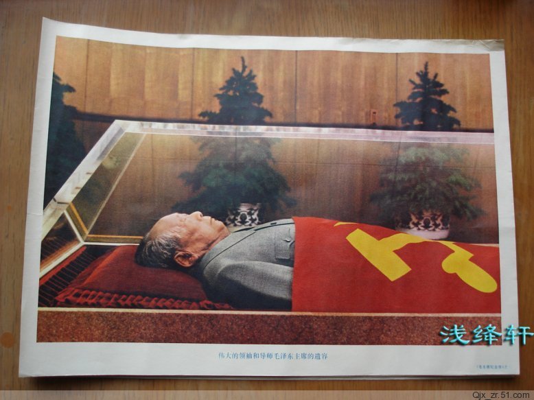
Chairman Mao in his crystal case 
Myself and Kevin started the day by getting up early and going over to Tiananmen Square to see the mausoleum of Chairman Mao.  Having already done trips to see the preserved bodies of Lenin and Ho Chi Minh in Moscow and Hanoi respectively, a part of me liked the idea of completing the “communist leader hat trick”.  Additionally, both of the aforementioned mausoleums were actually fascinating - both for being able to see the physical form of men who had shaped human history and also to watch the reactions of the tens of thousands of (mainly Chinese) people who file past on a daily basis.  In Moscow, the majority of visitors were morbidly curious westerners - but in Hanoi and now Beijing, the crowds were full of what were essentially mourners, some who cried at the sight of their dear leader’s body.  There were obviously no photos allowed inside, but I was able to find this one on the internet.

The Antiques Market
We picked up the others from the hostel and walked south to the Temple of Heaven Park, about two miles south of the Forbidden City.  The name is a bad translation - the location is not a temple, but is rather an 'altar’, where the Emperor used to come to make offerings to pray for good harvests and the like - though there are no monks, clouds of incense .  The main structure (shown above) is actually named the “Hall of Prayer for Good Harvests” and is one of the iconic sites in the city - though is actually smaller than I imagined.  The surrounding park is a haven of smaller shrines and gardens, with locals doing everything from Tai Chi to ballroom dancing, playing hacky-sack to badminton.  It must be said, that the Chinese make far better use of their public spaces than we do.  After some casual wandering we made our way east to the last sight of the trip, the antiques market at Panjiayuan.  I had expected the market to be a tourist trap, but it must be said the vast majority of people who were there were locals.  The goods on offer ranged from busts of Lenin to jade jewellery - and I was able to pick up a (supposedly first edition) English copy of Chairman Mao’s “Little Red Book”, which seemed appropriate having been to see him that morning.  With that, our time in Beijing was up and we made our way through the heavy traffic to the airport on what was yet another gloriously sunny afternoon, feeling thoroughly delighted that we had gone ahead with our spontaneous visit.

Share
Tweet
Pin
Share
No comments
Shwedagon Pagoda, Yangon
A mixture of colonial and Burmese at Maha Bandoola Park
Just over a week landing in Yangon at the start of the trip, we returned to the former capital as our final destination.  Known as Rangoon by the British, who made it their capital, it remained so until 2005 when the capital was moved north to Naypyidaw.  Historically, the capital of Myanmar had actually tended to be in the centre of the country at many of the places that we had already visited - from Bagan to Inwa to Mandalay, and the position of a capital in the south of the country (so-called Lower Burma) was actually the exception, rather than the rule.  Regardless, Yangon is still the largest city in the country with a population of nearly five million people - four times larger than Mandalay or Naypyidaw, the second and third largest cities respectively.   The city is arguably the heart of modern Myanmar, but it has only really been so since British rule and there is therefore a clear mix of influences between British and Burmese.

Colonial Architecture

As the last stop on our tour (and as the capital), I wanted to spend a little bit longer in Yangon and we therefore had two full days to explore.  The first thing we noticed upon arrival was the palpable difference in climate compared to all of the other destinations that we had visited - it was not only hotter (in the high 30s), but it was also far more humid.  Anybody who describes Burma as a tropical county is only telling half the story, but Yangon is absolutely a tropical capital.  On our first day we decided to follow the Lonely Planet walking tour of downtown at a very leisurely pace with lots of coffee breaks.  This started by walking through the colonial district where the beautiful buildings built by the British can be found.  It must be said, that for all of its many faults, the Empire did leave a legacy of some absolutely glorious buildings - some of which have been taken over as government departments but many of which stand disused.  Amongst these grand old buildings is a street known locally as the ‘open air library’, which is full of street book sellers.  Apparently the Burmese are massive readers and the titles that were on offer are an indication of how far the country has come - books such as Orwell’s “1984”, or Aung San Suu Kyi’s “Freedom From Fear” can be openly purchased despite being banned as recently as five years ago.  At the end of this street is the famous 'Strand Hotel’, once one of the most luxurious hotels in the British Empire - up there with the Raffles in Singapore and the Peninsular in Hong Kong.  It has been through some bad times, but is now once again back to something like its former glory and has a reasonably priced cafe, where we were able to have a break in the blessed air-conditioning.

The Strand Hotel, Yangon
Our walking tour took us briefly down to the river (though this was admittedly not much to look at), before heading back north along the British grid-system roads until we arrived at the market district.  The markets are where the locals get their food and they are a mix of spices, fruit, veg, meat and fish - with the smell of the latter two totally masking that of the former three foodstuffs… Surrounding the markets are a fascinating mixture of religious buildings - Christian churches, Jewish synagogues, Islamic mosques and Hindu and Buddhist temples, which are testament to how (rightly or wrongly) cosmopolitan Yangon became under British occupation.  After entering one of the Hindu temples and poking around the markets we were all flagging a little (the heat in Yangon was notable enough to make it into Noel Cowards “Mad Dogs and Englishmen” song - “the toughest Burmese bandit can never understand it, in Rangoon the heat of noon is just what the natives shun…”

Sunset over one of the city’s many pagodas
Inside the Shwedagon complex
Our last day in Yangon was to be spent visiting a few of the remaining sights while preparing for our various journeys back to Hong Kong (our group of eight would be returning along four different routes – two of the group had left last night).  After an interrupted night’s sleep in the unforgiving tropical heat, we rose late and got taxis north to the famous Shwedagon Pagoda – the most important temple in the country and one of the most impressive religious sights in the world.  I had passed nearby last night to watch the sunset but wanted to return to go inside.  At US$8, the pagoda is probably the most expensive attraction in all of Burma, but once you are inside and you see the sheer quantity of gold that makes up the network of stupas and shrines (not to mention the central pagoda itself), you start to understand why.  Unfortunately, having had to take our shoes off, we spent much of our visit running between shadowy areas as the stone floor must have been reaching temperatures high enough to fry an egg.  Local worshippers and monks were not spared from this either – definitely one of the design flaws in Buddhist temples.


Outside Aung San Suu Kyi’s house
With the Shwedagon seen, we felt we had done a good enough job of Yangon to do a bit more casual wandering before scuttling back to the hotel to make the most of the air conditioning during the unbearable afternoon heat.  By the time late afternoon had come around it was time for myself and Jeremy to say our goodbyes and make our way to the airport.  We had arranged for the company who had provided our driver to give us an airport transfer and were delighted to find that it was Jimmy, our driver for the whole trip, who came to collect us.  We weren’t particularly pushed for time and as we made our way north to the airport we asked Jimmy to briefly stop by at the house of Aung San Suu Kyi – where she was placed under house arrest for all those years.  Situated in a quiet, wealthy area, the house has no particular marking except for a range of flags and banners dedicated to her NDP party.  It was worth stopping by however as it is a place of great importance in Burmese history and something of a pilgrimage for admirers of the Lady herself.  Jimmy was obviously a massive fan – giving us a massive grin and thumbs up when we pulled up outside.  It was a fitting end to our time in Burma and very much felt like we were seeing part of a story that is still in progress.  I hope to be back.
Share
Tweet
Pin
Share
No comments
The ridiculous highway at Naypyidaw 
Today was unfortunately assigned almost entirely to travelling, with a 10 hour journey between Inle Lake and Yangon awaiting us.  As we had the advantage of the minivan and were limited on time, we had a look at our maps to see if we could find a place of interest en-route where we could have our lunch or stretch our legs.  The natural resting point of the journey would come at Nay Pyi Daw, the capital of Myanmar since 2006 when the government decided to move it from Yangon in the south. 


Three kids walking an elephant
A pointlessly top quality road network
The motives for this move depend on who you ask.  The western literature that I have read overwhelmingly supports the idea that the move was part military strategy (to move the capital away from its traditionally vulnerable coast and to put it in a better position to control the country’s ethnic minorities), part vanity project (to give the ruling elite a flashy new symbol of their power) and part superstition (a prophecy apparently suggested that the capital needed moving).  On the other hand, the history books that I have read which come out of Burma itself suggest that the move was nothing more than common sense – Yangon was crowded, had little room to expand and was located at the southern tip of a country three times the size of the UK (just think if the UK was three times larger and had its capital at Portsmouth…).  These historians point to both Brazil and Australia who both built new capitals at Brasilia and Canberra, away from the traditional cultural or economic powerhouses, in order to take up a more strategic position for the whole country.


The Myanmar Parliament Building
Before we arrived in the city at lunchtime (having left Inle Lake at 7am), I hadn’t decided which of the historical interpretations for the move I supported.  Upon arrival however, it became clear in my mind that the new city was nothing more than a huge vanity project.  After spending the morning driving along dirt roads in the mountains through poverty-stricken rural villages, we were met in Nay Pyi Daw by fountains, grand hotels and vast highways with not a car in sight.  We grabbed some lunch at a local cafeteria-style restaurant and then drove around the city a little, stopping outside the new parliament for some pictures.  It was here that the new city was at its most obscenely ridiculous.  In front of the grand building that contains the parliament is a highway which is wider than the M25, but on which, in the 15 minutes we waited and took photos, one motorbike passed us.  The road was so quiet that we were able to walk around all of its sixteen (yes, sixteen) lanes without even looking out for incoming traffic.  From this surreal experience of Naypyidaw, we carried on driving for another four hours or so to what is still the spiritual and cultural capital, Yangon where we just about had enough time to head out for some street food for our dinner.


Street Food in Yangon

Share
Tweet
Pin
Share
No comments
View from Inthein towards Inle Lake
A perhaps not so genuine fisherman 
Supposedly the highlight of any trip to Myanmar, and our last stop before returning to Yangon, is a visit to Inle Lake in the east of the country in Shan state.  Despite what the recent Top Gear may have told you, parts of Shan state are accessible to westerners and Inle is one of the main Burmese tourist sites and home to its biggest backpacking community (it is the eastern part of Shan state, along the border with Thailand, where fighting has occurred).  The lake is the second largest in the country and has achieved its fame due to its scenic setting, nestled in the Shan Hills, as well as the village communities that have developed around (and on) the water itself.  We were staying at the north end of the lake at Nyuang Shwe, where the majority of accommodation is and which is connected to the main body of water by a canal.  All of the hotels in the town are able to organize boat tours of the lake and that is how we decided to spend our full day at Inle.  Given a bit longer we would have loved to have spent some time hiking in the Shan Hills, but that may have to wait until another time…

Communities on Inle Lake

Kayan ‘giraffe’ women - an uncomfortable photo
Upon arrival at the lake we were met by the above photographed fisherman, who wanted us to pay to take his photo.  The actual fishermen of the lake are very iconic, coming out in the morning and navigating while balancing their baskets on one leg - but as the area has become something of a tourist trap, lots of fakes are beginning to cash in.  The boats (which are essentially long, four-seater canoes with a horrendously noisy lawn-mower engine on the end) have a monopoly on lake travel for tourists and as a result we had very little choice but to be ferried around via tourist shops.  While I was not to read the full story until the end of the day, we also came across some of the other victims of the new tourist trade - the long-necked 'giraffe’ women of the Kayan tribe.  Traditionally, women from the tribe would add a metal band to their neck every year to ceremonially stretch it.  Tourists are obviously fascinated by this, even though it actually looks repulsively painful, and many shops will now get the women to sit outside their shops to draw people in.  Over the years the rings essentially become an exo-skeleton, the removal of which would result in death - and many women are forced into wearing the rings for money-making rather than traditional reasons.  The United Nations recently described the women as being treated like circus animals and I will admit that looking at the photo that I took now makes me distinctly uncomfortable.

After telling out boat pilots that we didn’t want to see any more shops, and then grabbing some lunch, we tried our best to get a little bit off the standard tourist route by heading up an irrigation canal on the western side to the village of Inthein.  This quiet village contained a few touristy shops and restaurants, but was fare more laid-back than the rest of the lake that we had seen and also contained two large stupa-capped hills with views back towards the lake and the surrounding rice paddies.  The crumbling ruins at the hills were worth a visit, even without the views, and I would thoroughly recommend any visitors to Inle to try to get to Inthein.  Our last stop, now on our way back to Nyuang Shwe, was the so-called 'jumping cat’ temple, where bored monks supposedly have taught their feline co-residents to jump through hoops.  Astonishingly, as we arrived at the temple we found ourselves in a massive hail storm which had arrived totally out of the blue, and we found ourselves running inside to take shelter.  We were incredibly lucky with our timing - had we spent an extra 10 minutes in Inthein we would have been left totally vulnerable to the massive hail stones in the middle of the lake.  Unfortunately, the monks weren’t in the mood to make the cats jump, but we were still thankful to spend some time in the temple out of the storm.  The storm left as quickly as the it had arrived and we were able to get back to the town without any further incident.  That night we decided to splash out on food a little and went to the Shan Restaurant at the ViewPoint Lodge, where a wonderful set menu gave us a great introduction to the local cuisine in a great setting.
A stupa capped hill at Inthein
The hailstorm
Dinner at the ViewPoint Restaurant

Share
Tweet
Pin
Share
No comments
U-Bein Bridge
We had, admittedly, not really seen much of the sights of the city of Mandalay itself, though having fully experienced the water festival however, we felt that this was a suitable trade-off.  There was one more location that we wanted to (re)visit however and that was U-Bein Bridge.  We had already seen it at sunset, but we had heard that the most beautiful time to see it was sunrise, when it is quieter and the monks cross it to collect their daily alms.  This meant checking out of our hotel at about 5.30am, but that wasn’t too much of a hardship considering that it would allow us to see more throughout the day and reach our eventual goal (Inle Lake) earlier.  While the sunrise itself was pretty hazy, arriving at the bridge early was well worth it for the peaceful calm at the lake and the wonderful pictures we were able to capture, my favourite of which is above.
A random religious hill top on
From here it was to be a long eight-hour drive through the hills to Inle Lake.  I had asked Jimmy if he was willing to stop off about three-quarters of the way through the journey at a place called Pindaya, a major site of religious pilgrimage which is based around a cave, stuffed full of Buddha statues.  There are thought to be over 8,000 statues of the Buddha, donated and collected from all over the world. Tourists have to pay a $5 entrance fee, but this is well worth it as the caves alone are impressively dramatic, not to mention the amount of golden Buddhas inside them.  We only stayed for about an hour or so before continuing the remaining two hours to Inle - for anyone with a large amount of time at the lake, Pindaya would make a good half-day excursion.  We arrived at about 6pm at the town of Nyuang Shwe, the tourist hub at the northern end of the lake.  While there was no time to go out on the lake itself, we were able to wander around the town a little bit, grab some food and then took some beers back to the hotel terrace.

Pindaya Caves

Pindaya Caves

Share
Tweet
Pin
Share
No comments
Both sides of the island at once - the view from Violet Hill
The hiking book that I purchased back in October contains a total of 15 hikes, spread across all of the territory.  It had always been my intention to complete all of them and as my final month began, I realised that I would have to get a move on to achieve this.  As a result I decided to stitch a few of these hikes together - a process that was made easy by the excellent “Historical Hikes of Hong Kong” book by David Pickerell that I had been using.  I left the campus early and was at the bus station beneath the IFC by 10am.  The start point for both hikes was at ‘Hong Kong Parkview’, a luxury residential area locating on the heights above the harbour.  In order to get there I would have to take a Stanley-bound bus from Central.  Unfortunately, having aimed to get the number 6, I caught the number 6X.  The 'X’ apparently symbolises the fact that the bus route goes through the tunnels underneath the island, rather than through the passes above it, where the hike starts - and I therefore ended up wasting an hour or so, having gone directly underneath the trail-head, getting a taxi from Repulse Bay to rectify my mistake.

The start of the first hike - steps up to the right
Starting from a well-marked point next to Parkview, I followed signs for the Violet Hill and Tai Tam reservoir, the former of which I climbed to the top of and the latter of which I spent the first half of the first hike skirting around.  It was reasonably busy, being a Saturday morning, but there were still plenty of moments where there was nobody else about.  It soon became clear that this was going to be one of the most spectacular hikes I had done, as each turn brought better and better views of all of Hong Kong Island - first over Victoria Harbour on the north side, then over Aberdeen, Repulse Bay and Stanley on the south side, not to mention the views over the beautiful reservoirs and forests of Tai Tam Country Park.  After a steep initial climb, the ascent to Violet Hill wasn’t too hard and from there it was a gentle descent towards 'The Twins’ (a pair of very steep-sided peaks) and Repulse Bay.  At the foot of the twins, footpaths head off in all directions.  I took the right pass towards Repulse Bay, following signs for Wong Nai Chung Reservoir.  The path was now flat and followed the south side of the island with views towards  Ocean Park, Lamma Island and in the distance Cheung Chau.  About two and a half hours after I began I found myself at the Wong Nai Chung Reservoir - a tiny reservoir that was deemed too small to be worth maintaining for the purposes of drinking water and is now a boating lake.  From here it was about a 400m climb back to Parkview where I started and would also begin my second hike.

The start of the second hike - through the arch
The second hike was to head west along Hong Kong island, towards the peak, before veering north and east again, finishing at Quarry Bay station.  This hike again started with a steep hike up towards Jardine’s Lookout.  Along the way, a plaque marked the position where Canadian soldiers fought of the Japanese invasion during the war - with a Victoria Cross being rewarded to a Sergeant-Major Robert Osborn, who through himself on a grenade to protect his comrades.  After about half an hour of climbing I made it to Jardine’s Lookout, which had one of the best views of the harbour I have seen.  The peak’s name came from the fact that it used to be where representatives of Jardine Matheson (the opium house that was pivotal in the foundation of Hong Kong) used to come to wait for ships to arrive from Europe.  Legends has it that their ships used to signal insider information about the European stock markets to the hill, allowing the company to gain a commercial advantage on the Hong Kong markets…

The hike now headed downhill steeply towards a large quarry (after which Quarry Bay station is named) and with Tai Tam reservoir always visible to the right.  After another steep climb along the side of the quarry I arrived at a hill with views over the lesser-known east end of Victoria Harbour, from where I descended to Quarry Bay MTR station and headed back to the campus.  While both hikes together were quite a lot of work (about five and a half hours of reasonably intense hiking in total), it was definitely worth seeing both of them together and an achievable goal for anybody wanting to see a different side of Hong Kong while being pushed for time.

Tai Tam Reservoir
Repulse Bay and the south side of the island
Victoria Harbour from Jardine’s Lookout
The eastern end of Victoria Harbour

Share
Tweet
Pin
Share
No comments
Newer Posts
Older Posts

Search This Blog

About me

About Me


Aenean sollicitudin, lorem quis bibendum auctor, nisi elit consequat ipsum, nec sagittis sem nibh id elit. Duis sed odio sit amet nibh vulputate.

recent posts

Follow Us

Blog Archive

  • ▼  2017 (7)
    • ▼  October (7)
      • South Africa’s 44 blue flag beaches for 2017
      • Europe’s most glam holiday destinations is French ...
      • Alcohol helps you speak foreign languages better, ...
      • Government to cut pilot evaluators for large airli...
      • Nepal POKHARA Day#3
      • Nepal RAMKOT Travel Adventure - Day #2
      • Nepal Bandipur Travel Adventure - Day #1
  • ►  2014 (76)
    • ►  November (8)
    • ►  August (6)
    • ►  July (5)
    • ►  June (10)
    • ►  May (15)
    • ►  April (1)
    • ►  March (4)
    • ►  February (10)
    • ►  January (17)
  • ►  2013 (12)
    • ►  December (1)
    • ►  November (6)
    • ►  September (4)
    • ►  August (1)
  • ►  2012 (27)
    • ►  September (10)
    • ►  August (15)
    • ►  July (1)
    • ►  May (1)
  • ►  2011 (73)
    • ►  September (8)
    • ►  August (15)
    • ►  July (3)
    • ►  June (11)
    • ►  May (24)
    • ►  April (3)
    • ►  March (3)
    • ►  January (6)
  • ►  2010 (27)
    • ►  November (11)
    • ►  September (9)
    • ►  August (7)
  • ►  2009 (14)
    • ►  August (8)
    • ►  July (5)
    • ►  June (1)

Labels

10000 Camellia Blossom Temple airlines Albania Amedi Amediyah Anzac Anzac Cove Aphrodisias Assos Austrian Airlines Erbil Ayvalik Backpacking Iraq Backpacking Kurdistan Baisha Bandipur Basilica Cisterns Behramkale Bekhal Waterfall Berat Bergama Beyoglu Bitola Blue Flag Beaches Blue Mosque Bosnia Hercegovina Budva canada Cappadocia Cerro Ena China Corcovado National Park Costa Rica Crowded House Hostel Dali Dohuk Dohuk Dam Donald Duoyishu Eceabat Education England Ephesus Erbil Erhai Lake Family Mall Erbil Freddy's Hostel French Concession FYROM Galata Tower Gali Ali Beg Waterfall Gallipoli Gloucestershire Goreme Hagia Sophia Halfway Guesthouse Hamilton Road Heraklea Hierapolis Hitchin Boys School Hostel Pangea Hotel Qandeel Huangpu River Cruise Iraq Iraqi Kurdistan Istanbul Jade Dragon Snow Mountain Jajce Jianshui Karst Landscape Kotor Kunming La Fortuna La Gran Vista Lake Ohrid Lalish Temple Lijiang Limestone Lone Pine Cemetary Luijazui Macedonia Montenegro Monteverde Mostar Napal news Osa Peninsular Pacuare Pamukkale Pergamum Pigeon Valley Pliva Lakes Pokhra Port Jim Puerto Jimenez Qing Architecture Ramkot Rawanduz Gorge Red Basilica Red Valley regular Roman Rose Valley Rozafa Fortress San Jose Selcuk Shanghai Shanghai Museum Shilin Shkoder Shkodra Shuhe Skopje South Africa Stone Forest Sulav Suleymaniye Mosque Sveti Stefan Tamarindo The Bund The Confucian Temple Three Pagodas Tiger Leaping Gorge Tirana Topkapi Palace Travel Travel Adventure Travertines Troy Turkey Turtle Sanctuary Twin Dragon Bridge Ulcinj Urban Planning Museum Usichar Volcan Arenal Watermills World Challenge Xinjie Yazidi Yazidians Yuanyang Rice Terraces Yunnan Province

Follow Google +

Unknown
View my complete profile
FOLLOW ME @INSTAGRAM

Created with by BeautyTemplates